MULTIPLE-SCAN VELOCITY RESOLVER
METHOD:
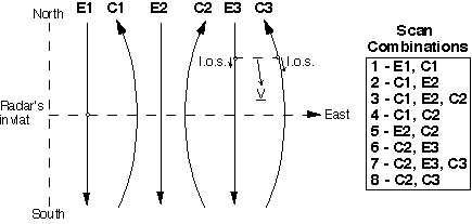
· Elevation scans along the magnetic meridian are bracketed by composite
scans (combined azimuth and elevation angles) that provide measurements
in planes parallel to the magnetic meridian but offset by about 100 km
at F-region altitudes to the east and west . Elevation scans are directed
N -> S and composite scans are directed S -> N.
· Ion drift velocities are resolved by combining line-of-sight
(l.o.s.) measurements of ion velocity from elevation scans (E) and composite
scans (C) within common altitude and invariant latitude bins. The process
is applied to all data between 180 and 500 km altitude.
· Numerous combinations between scans are possible depending
on temporal and spatial resolution constraints, as illustrated in the box.
ASSUMPTIONS:
· Everything ExB drifts from 180 km up
· Time invariance between line-of-sight pair measurements
· Flow is longitudinally uniform at the latitude of the line-of-sight
pairs
SPATIAL RESOLUTION:
· Governed by pulse length, scan rate and orientation. Typically
0.2° in latitude, 100 km in longitude, 50 km in altitude
· 10° latitudinal coverage
TEMPORAL RESOLUTION:
· Maximum 45 sec. (at pairings where elscans end and compscans begin).
Resolution of 4 min. for l.o.s. pairings at mid-point of scans. Lowest
resolution 12 min